| About | 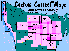 |
Return to Little River Enterprises |
| Return to Home Page |
| About | |
Return to Little River Enterprises |
Custom Correct Maps are the most used and respected topographic trail maps for the Olympic Peninsula. They have the same professional look as a U. S. Geological Survey 15' topo map, including the standard 1:62, 500 scale (1 inch to the mile). However, instead of the USGS "quad" format, each map is laid out to include an entire area of interest, and entire trail systems on a single map. Trails were carefully field checked, remapped and depicted with easily visible red lines or dashes (depending on the maintenance class of the trail), with accurate distances in both miles and kilometers.
The idea for the first Custom Correct Map started in 1983 out of frustration at the available topographic maps of the Hurricane Ridge area. The area is at the intersection of four USGS quads, all either out of date, or inaccurate to begin with. The result was the creation of Hurricane Ridge and Vicinity, its success led to the entire series of Custom Correct Maps, now the best selling hiking maps for the Olympics. Each map is "Custom" covering a complete trail system so you don't have to walk off the map (unlike the old quads). and "Correct" because each trail was personally field checked and re-mapped.
Despite advancing technology, Custom Correct Maps are still essential on the trail. You may have all the newest 7½' quads, but none are as up-to-date as the corresponding Custom Correct map, including the latest digital download or CD-ROM - and you'll walk off each of those maps and be piecing them together before you finish your hike. Even if you do a custom printout from your CD-ROM on your color inkjet, one drop of rain or sweat and the colors will run.
In the past, trails have been mapped primarily from aerial photos, but since most trails in the Olympics are forested, they don't show up on the photos. This left a lot of guesswork, and inaccuracy. To correctly map the trails, I walk each trail with a measuring wheel and altimeter, taking distance and elevation readings at every mappable point (about 20 data points per mile). This field data is processed, and each trail is then plotted onto the topography and features of the base map, one point at a time. The results are often quite different from the old map's routes.
So, if you've ever been lost, and thought you couldn't read a map, don't be too hard on your-self...It may have been the map's fault! Many of the worst errors I've re-mapped are the very same spots famous for getting people lost!
The USGS has finally finished the entire 7½' series of quadrangle maps. Consequently they have now abandoned the 15' series. This means that Custom Correct maps are now the only published maps for the Olympic Peninsula at this scale. Many outdoor enthusiasts will find the detail of the 7½' maps to be very useful, others will find no reason to haul around seven times the paper, just to walk off each sheet much faster. Either way, you'll always want to carry your Custom Correct map of the area to keep you oriented to the entire trip without losing the needed detail. (The USGS crews used them while field checking for the new 7½' quads) To help you stay oriented, the newest Custom Correct map revisions include a key showing which 7½' quads cover the same map area. And although they are new by USGS standards, even the newest 7½' quads are no longer as up-to-date as their corresponding Custom Correct maps. (see below)
Fifteen of the sixteen Custom Correct maps have been revised and updated since 1990, and the newest, best map information is always included. Consequently, much of the base map detail found on 7½' quads is now on Custom Correct(tm) Maps. Above all, the trail information is always up to the minute, including new trails, like the Mount Muller Loop on Lake Crescent - Happy Lake Ridge (1994).
There has been a lot of improvement to most of the original maps. Hurricane Ridge and Graywolf - Dosewallips were redone from scratch. Seven Lakes Basin - Hoh is already into it's fourth generation! In addition to updating information, the recent revisions have brought all Custom Correct(tm) Maps up to consistent cartographic standards. The size is uniform, and the boundary shading, colors, and legends, etc. are consistent. But the standards keep going up: revised maps get the 7½' quad key and the shift to NAD 83 (see below).
Check the map list below the index map. The publishing date is shown for each map. It may be time to recycle your old map and get up to date with a newly revised Custom Correct map.
Enchanced Custom Correct Features
Magnetic North Declination
The Earth's magnetic poles are not at the actual poles, so your compass doesn't point north, it points to magnetic north. The difference between true north and magnetic north is called the magnetic north declination (or correction factor). If you look on a Custom Correct or USGS topographic map, you will see two lines spitting off from the north arrow. The one on the right is labeled with the magnetic north "declination", When your compass arrow points at that number, the 'N' points to true north.
That much you probably already knew, but did you know the declination is constantly changing? On the Olympic Peninsula it is decreasing at a rate of one degree every fifteen years. Consequently, older maps will show declinations up to 23º. The 1999 declination for most of the Peninsula is about 20º, a little higher in spots.
North American Datum of 1983
Even if magnetic North wanders around, at least Latitude and Longitude are constant, right? Wrong! Theoretically they are, but recently the basic refer-ence points for North America were re-surveyed with state of the art technology, to correct the 1927 reference points (or "datum") upon which older maps are based. A conversion is now underway to describe and show locations relative to the more accurate "North American Datum of 1983" ("NAD 83"). Satellite data and Global Positioning System (GPS) devices use the new datum exclusively. For the Olympic Peninsula this means moving longi-tude lines 96 meters (315') east, and latitude lines 24 meters (77') north. It also shifts the UTM grid the same amount, since it is based on latitude and longitude. As the use of portable GPS devices increases, this shift will become more important, since all satellite data is NAD 83.
Once again Custom Correct maps are ahead of the rest. Nine of the most recently revised maps have been completely shifted to the new datum. On these, there are ticks in the map corners showing the offset back to the old reference points (and old maps). In the meantime, USGS quads and older Custom Correct maps include small ticks in each of the corners showing the offset to the "new" (real) position on the Earth. (Most other brands don't even give you that!)
Nobody's perfect, mistakes even get onto Custom Correct Maps, and features keep changing. The recent revisions, have corrected or updated most of the discrepancies, but here are the remaining ones, so you can note them on your own maps.
North & South Olympic Coast,
Ozette Beach Loop
Both coastal maps show maximum tide heights for safe passage around restrictive
headlands. Since the measurements were made, several of the headlands have
changed significantly. This tidal and wave action is constant and unpredictable,
so there is no way to know, from one season to the next, exactly what the
conditions will be. Watch for posted information at trailheads, and make local
inquiry. Specific known discrepancies are as follows: The sticky spot just north
of the Hoh River mouth (South Olympic Coast) requires a lower tide than that
shown: instead of 4 ft, aim for 0-2 ft. The headlands of Browns Point, just
south of Beach #3 at Kalaloch (South Olympic Coast) may require a lower tide
than the 3 ft and 5 ft tides shown, some hikers report the need for a minus tide
to feel safe rounding these points. In addition to changes in the beach, storms,
offshore winds or other unpredicted factors can make the tide higher than
predicted by the tide tables.
North Olympic Coast
Access to Shi Shi Beach from the North is again available through the Makah
Reservation! There is a new trailhead, 1/4 mile southeast of the old route, on
Fish Hatchery Road. This is a day-use only trailhead. If you want to park
overnight, you must pay for parking at one of the posted locations just before
reaching the trailhead. Unfortunately this now trail bypasses very little of the
mud.
The trails to Cape Flattery were rebuilt in 1997. The alignment shown on the map is substantially correct, but it is no longer a way trail.
The Brothers - Mt Anderson
The Dosewallips Road is closed by a landslide just below Elkhorn
Campground, 5.5 miles below the Dosewallips Campground, Trailhead and Ranger
Station. Due to the severe topography and engineering complexity of the
situation, there are currently no plans to repair it. An acceptable solution has
not yet been found.
Most people who visit the backcountry of the Olympic Peninsula drive to the trailhead on their own and hike from there. But there are alternatives...
The Bus
The Clallam Transit bus between Port Angeles and Forks passes the
Barnes Creek/Marymere Falls trailhead on Hwy 101 (Lake
Crescent-Happy Lake Ridge). The bus between Forks and La Push
passes the Second and Third Beach trails (South Olympic Coast).
On winter weekends there are busses to Hurricane Ridge also. And
of course you can get to Port Angeles by bus or ferry. Call
Clallam Transit at 452-4511 for schedules.
Olympic Van Tours provides transportation between Port Angeles and the Hurricane Ridge, Elwha, Soleduck, Hoh, and other trailheads (by reservation). Call 452-3858 for more information.
Mountain Biking
More and more people are bicycling to and beyond the trailhead.
Bicycles are NOT allowed on trails in the Wilderness Areas or in
Olympic National Park, except the "Spruce Railway
Trail" (Lake Crescent-Happy Lake Ridge). However
there are some Dept. of Natural Resources trails and many
National Forest trails where bikes are allowed, including most
trails that don't lead into a Wilderness Area. (Call 360-956-2300
for info.) A few suggestions: "Gold Creek-Lower
Dungeness" loop and "Lower Big Quilcene" (Buckhorn
Wilderness), "The Foothills Trail" (Hurricane
Ridge), "Sadie Creek" and "Mount Muller"
(Lake Crescent-Happy Lake Ridge), and "Lower South
Fork Skokomish" (Mount Skokomish-Lake Cushman).
These days mountain bikes offer an added advantage. Since many roads that access trailheads have sustained severe winter storm damage, they may not be open to motor vehicles, especially early in the season. Bicycles, however, can still make it on most of them. (Bring a lock so you can leave your bike at the trailhead when you hike in!)
| Next Page:How To Find Which Map(s) You Need | Back to Top | Return to Home Page |
Copyright © 1999 Little River Enterprises
Last revised: July 20, 2009.