| NEW!
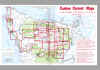
For a detailed Olympic Peninsula Map Index to both Custom Correct
and USGS Maps , Download the Full Color Index Map (High resolution compressed JPEG: 553K, 3-6 min. download time ) |
|
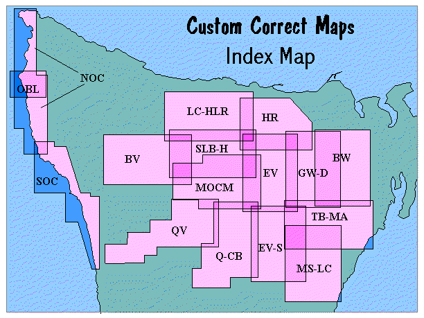
How To Find Which Map(s) You Need
If you know
the area you are interested in, find it on the generalized map below.
The initials on this map correspond to the map initials in the
table below
| NEW!
For a detailed Olympic Peninsula Map Index to both Custom Correct
and USGS Maps , Download the Full Color Index Map (High resolution compressed JPEG: 553K, 3-6 min. download time ) |
|
If you know the trail(s) you want to see by name, look them up in the index following the key.
|
The initials in the table
to the left correspond both to the initials in the map outlines on the index map above, and to the initials in the "MAP" column of the trail index table below.
The initials in the small
table above |
||||||||||||||||||||||||||||||||||||||||||||||
Index to Olympic Peninsula Trails
Custom Correct (tm) Maps are specially designed to include entire trail systems on each map. So, for any trail, you never need more than one map. To do this, the maps overlap, rather than tiling, as quad maps do. Consequently for many trails contained in the overlap areas, you have a choice: either map will cover the whole trail. Longer routes may string together enough individual trails that you need more than one map.
Multiple map initials indicate overlapping coverage of the trail, with the primary map's initials listed first. Unless (pt) follows the map initials, the trail is totally contained on that map.
(pt) after one of the map initials indicates that only part of the trail is on that map. A few peripheral trails with (pt) after the trail name are only partly contained on a single map.
Names in brackets after the trail name are alternate names for that trail. Parentheses after the trail name further describe the trail.
| Trail | Map(s) | Agency |
| Allen's Bay | NOC | U |
| Anderson Glacier | TBMA, EVS | P |
| Anderson Pass | TBMA, EVS | P |
| Appleton Pass | SLBH | P |
| Aurora Creek | LCHLR | P |
| Aurora Ridge | LCHLR | P |
| Badger Valley | GWD, EV, HRpt | P |
| Barnes Creek | LCHLR | P |
| Barnes Creek (Upper) | LCHLR | P |
| Big Creek Campground Loop | MSLC | F |
| Big Quilcene (Lower) | BW | F |
| Big Quilcene (Upper) | BW | F |
| Black and White Lakes | EVS, MSLC | P |
| Blue Glacier Moraine | MOCM, SLBH | P |
| Blue Glacier Terminus | MOCM, SLBH | P |
| Blue Mountain | GWD, HR | P |
| Bogachiel Peak | SLBH, MOCM | P |
| Bogachiel River | BV, SLBHpt | P |
| Boulder Lake | SLBH, LCHLR | P |
| Brown Creek Campground | MSLC | F |
| Cameron Creek | GWD | P |
| Cameron-Lost Pass | GWD, EV | P |
| Cape Alava | NOC | P |
| Cape Flattery | NOC | T |
| Cascade Rock | LCHLR, HR | P |
| Cat Basin | SLBH, MOCM | U |
| Cat Peak | SLBH, MOCM | U |
| Cedar Lake | GWD | P |
| Charlia Lakes Way | BW, GWD | U |
| Colonel Bob | QCB | F |
| Constance Pass | BW, GWD | P, F |
| Cox Vally | HR, EV | P |
| Crystal Ridge | LCHLR, SLBH | U |
| Deer lake | SLBH | P |
| Deer Ridge | GWD, BWpt | F, P |
| Dirty Face Ridge | BW | F |
| Dodger Point Way | EV | P |
| Dosewallips River | GWD, BWpt | P |
| Dry Creek | EVS, MSLC | F |
| Duckabush (Upper) | EVS, TBMA, MSLC | P |
| Duckabush River | TBMA | F, P |
| Dungeness (Upper) | BW, GWD | F |
| Dungeness River (Lower) | BW | F |
| Eagle Lakes | LCHLR | P |
| Elip Creek | QCB | P |
| Elk Lake | MSLC | F |
| Elk Mtn [Elk Mtn Cutoff] | GWD, EV, HR | P |
| Elwha Basin | EV, MOCM | U |
| Elwha Campground Loop | LCHLR | P |
| Elwha River | EV | P |
| Enchanted Valley | EVS | P |
| Ericson's Bay | NOC | P |
| Finley Peak | QCB | U |
| First Divide | EVS, TBMA, MSLC | P |
| Flapjack Lakes | EVS, MSLC | P |
| Fletcher Canyon | QCB | F |
| Foothills | HR | D |
| Four Stream | EVS, MSLC | U |
| Goblin Gates | EV, HR, LCHLR, SLBH | P |
| Gold Creek | BW | F |
| Goodman Creek Headland | SOC | P |
| Grand Lake [Lillian Ridge] | GWD, EV | P |
| Grand Pass | GWD, EV | P |
| Graves Creek Nature | EVS, QCB | P |
| Graves Creek [Lake Sundown] | EVS | P |
| Gray Wolf Pass | GWD | P |
| Gray Wolf (Lower) | GWD, BW | F |
| Gray Wolf River (Upper) | GWD | P |
| Griff [Griff Creek] | LCHLR, HR | P |
| Hall of Mosses Nature | MOCM, SLBH, BV | P |
| Happy Lake Ridge | LCHLR | P |
| Hart Lake | TBMA, EVS, MSLC | P |
| Hart Pass | TBMA, EVS | U |
| Hayden Pass | EV | P |
| Heather Creek | BW, GWD | U |
| Heather Park [Mount Angeles] | HR | P |
| High Divide | SLBH, MOCMpt | P |
| Hoh Head Headland | SOC | P |
| Hoh Lake | SLBH, MOCM | P |
| Hoh River | SLBH, MOCM | P |
| Hoh-Bogachiel | BV | P |
| Hoodsport Trail State Park | MSLC | S |
| Humes Ranch | EV, HR | P |
| Humptulips River (Upper) (pt) | QCB | F |
| Hurricane Hill | HR | P |
| Hurricane Ridge Nature | HR, EV | P |
| Indian Pass | BV | P |
| Irely lake [Big Creek][Three Lakes] | QCB | P |
| James Pond | SOC | P |
| Jefferson Lake | MSLC | F |
| Jefferson Ridge | MSLC, TBMA | F |
| Kalaloch Beaches | SOC | P |
| Kalaloch Loop | SOC | P |
| Krause Bottom | EV, HR, LCHLR, SLBH | P |
| La Crosse Pass | TBMA, EVS | P |
| Lake Angeles-Klahhane Ridge | HR | P |
| Lake Constance | BW, GWD | P |
| Lake Creek [Heart O' the Hills] | HR | P |
| Lake Cushman State Park | MSLC | S |
| Lake La Crosse | TBMA, EVS, MSLCpt | P |
| Lake Mills | LCHLR | P |
| Lake Mills (Upper) | EV, HR, LCHLR, SLBH | P |
| Lake of the Angels | MSLC, TBMA | U |
| Lake Quinault Nature Trails | QCB | F |
| Lake Success | EVS | U |
| Lena Lake | TBMA, MSLC | F |
| Lillian River | HR, EV | P |
| Little Divide | SLBH | P |
| Little Quilcene | BW | F |
| Little River | HR | P, D, F |
| Long Ridge | EV | P |
| Lover's Lane | SLBH, LCHLR | P |
| Low Divide | EV, MOCM | P |
| Ludden Peak Way | EV, MOCM | U |
| Lunch Lake | SLBH | P |
| Maiden Peak [Elk Mtn], [Obstr. Pt.-Deer Park] | HR, QWD, EVpt | P |
| Marmot Pass | BW, GWD | F |
| Martin's Park | EV, QCB | P |
| Marymere Falls | LCHLR | P |
| Maynard Burn Way [Baldy Way] | BW, GWD | U |
| Mildred Lakes | MSLC | F |
| Mink Lake | SLBH, LCHLR, BV | P |
| Mora Loop | SOC | P |
| Mount Angeles Approach | HR | U |
| Mount Ellinor | MSLC | F |
| Mount Hopper | EVS, TBMA, MSLC | P |
| Mount Jupiter | TBMA | P |
| Mount Muller Loop (pt) | LCHLR | F |
| Mount Olson | EVS | U |
| Mount Olympus Climbing Routes | MOCM | C |
| Mount Rose | MSLC | F |
| Mount Townsend | BW | F |
| Mount Washington | MSLC | F |
| Mount Zion | BW | F |
| Muscott Creek | TBMA, BW, GWD | U |
| Ned Hill | GWD, BW | F |
| North Fork Quinault | QCB | P |
| North Fork Sol Duc | LCHLR | P |
| O'Neil Pass | TBMA, EVS, MSLCpt | P |
| Oil City | SOC | P |
| Old Lower Dosewallips | TBMA, BW, GWD | U |
| Olympic Hot Springs | SLBH, LCHLR | P |
| Oyster Lake | SLBH | P |
| P. J. Lake | HR, EV | P |
| Peabody Creek | HR | P |
| Peabody Creek Nature | HR | P |
| Pete's Creek | QCB | F |
| Pete's Creek (Lower) | QCB | F |
| Point of the Arches Headland | NOC | P |
| Price Lake (N&S) | MSLC | U |
| Putvin | MSLC, TBMA | F |
| Pyramid Mountain | LCHLR | P |
| Queets River | QV | P |
| Ranger Hole | TBMA | F |
| Rialto Beach | NOC, SOC | P |
| Royal Basin | BW, GWD | P |
| Royal Basin (Upper) | BW, GWD | U |
| Ruby Beach | SOC | P |
| Rugged Ridge | BV | F, P |
| S. Skokomish River (Lower) | MSLC | F |
| S. Skokomish River (Upper) | EVS | F, P |
| Sadie Creek | LCHLR | D |
| Sam's River Nature | QV | P |
| Sand Point | NOC | P |
| Scout Lake | TBMA, MSLC | U |
| Second Beach (La Push) | SOC | P |
| SEEK | EV, HR, SLBH | U |
| Seven Lakes Way Trails | SLBH | U |
| Shady Lane | EVS, MSLC | P |
| Shi Shi Beach | NOC | U |
| Siebert Creek Boundary | HR | U |
| Silver Creek | BW | U |
| Silver Lake | BW | F |
| Six Ridge | EVS | P |
| Skokomish River | EVS, MSLC | P |
| Skyline | QCB | P |
| Slab Camp | GWD, BW | F |
| Slide Camp [Baldy Way] | GWD, BW | U |
| Smith Lake | EVS, MSLC | P |
| Sol Duc Falls | SLBH, LCHLR | P |
| Sol Duc River | SLBH | P |
| South Fork Hoh River | MOCM | P, U |
| Spruce Nature | MOCM, SLBH, BV | P |
| Spruce Railway | LCHLR | P |
| Staircase Rapids | EVS, MSLC | P |
| Sundown Pass | EVS | P |
| Sunrise Ridge | HR | P |
| Switchback | HR | P |
| Taylor Point Headland | SOC | P |
| The Brothers Approach | TBMA, MSLC | F, U |
| Third Beach (La Push) | SOC | P |
| Three Forks | GWD | U |
| Three Horse Lake | SLBH, LCHLR | U |
| Tshletshy Creek (Lower) | QV | U |
| Tshletsy Creek (Upper) | QCB | U |
| Tubal Cain Mine | BW, GWDpt | F |
| Tunnel Creek | BW | F |
| Upper Lena Lake | TBMA, MSLC | F, P |
| Vern Samuelson [Valley Creek] | HR | O |
| Wagonwheel Lake | EVS, MSLC | P |
| West Elwha | LCHLR | P |
| West Fork Dosewallips River | TBMA, GWDpt | P |
| Willaby Creek [Big Cedar] | QCB | F |
| Willoughby lake | NOC | U |
| Wolf Creek | HR, EV | P |
| Wynoochee Pass | EVS | P, F |
| Next Page: Where to Buy Custom Correct(tm) Maps | Back to Top | Return to Home Page |
Copyright © 2001 Little River Enterprises
Last revised: September 24, 2001.