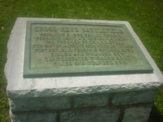
Cross Keys
8 June 1862
The
The 74th’s first battle was that of Cross Keys. In the early Summer of 1862, the Union Army was
hoping to capture Con. Gen. Stonewall Jackson in the
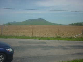
The valley floor is undulating hills with high steep mountains
that gradually rise from the valley and then steepened towards the summit. With the forested hills, they were impassable
by large scale forces, and difficult to cross over by just a few
individuals. The valley was served by a
main road that was predominately used by wagon’s – the river being the
predominate feature. The valley was
vital to the Confederacy – it was the “breadbasket” of
In late May, at Front Royal,
On the 8th of June 1862, the small
At 8:30 a.m., Cluseret’s Brigade came into contact with the
Confederate Army of Gen. Jackson. What
Cluseret didn’t know at the start was that the 15th
 Bohlen’s
Brigade (74th and 75th PA, 54th and 58th
NY,
Bohlen’s
Brigade (74th and 75th PA, 54th and 58th
NY,
As the men came into position as the far left of the Union line,
the heat in the middle was getting more intense as the Confederate forces began
pushing on Stahel’s wounded  brigade. Bohlen’s forces took positions on a
relatively rolling piece of ground in and about the Ever’s Farm.
brigade. Bohlen’s forces took positions on a
relatively rolling piece of ground in and about the Ever’s Farm.
The rolling terrain is such that even today, one can quickly see
how regiments were not easily seen.
Trees were more common in the region than today and the small creeks
that cut through the landscape provided cover for moving troops. At 2:30 p.m., the Colonel Hamm’s men were
formed into a line of battle by Gen. Bohlen.
As that took place, General Blenker decided to take a very acute
interest in the manner in which the brigade and the regiments therein were to
proceed. Rather than focusing on the
overall strategy of his division, Blenker at about 2:40 p.m. detailed companies
A & G to act as skirmishers without reserves and then specifically ordered
the men to protect the wounded of the 8th NY that were believed by
Blenker to be coming towards this part of the line.
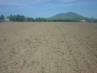
 From the
position near this turkey breeding farm, the regiments moved towards the left
of the photograph. The 8th NY
was in about the center of the picture where woods can still be found
today. As the regiment began to slowly
advance behind it’s skirmishers, the 13th
From the
position near this turkey breeding farm, the regiments moved towards the left
of the photograph. The 8th NY
was in about the center of the picture where woods can still be found
today. As the regiment began to slowly
advance behind it’s skirmishers, the 13th
Still proceeding cautiously, and following the order not to fire
at men in front of them with the expectation that any such men would be the
wounded of the 8th NY, the skirmishers advanced through the wheat
field.
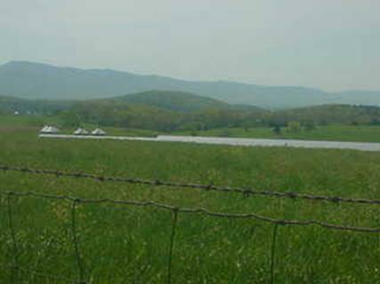
The wheat field would have been in this lowed area – still used
for such crops  today. The farmer informed us that the ground isn’t
the greatest for crops due to the amount of rock in it. The skirmishers would have advanced from the
today. The farmer informed us that the ground isn’t
the greatest for crops due to the amount of rock in it. The skirmishers would have advanced from the 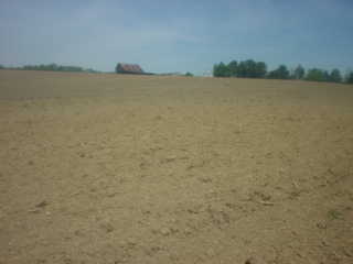 gracious,
as well as pleased that we stopped to ask him if we could walk on his
property. PLEASE DO NOT GO ON PRIVATE
PROPERTY WITHOUT PERMISSION OF THE OWNER.
gracious,
as well as pleased that we stopped to ask him if we could walk on his
property. PLEASE DO NOT GO ON PRIVATE
PROPERTY WITHOUT PERMISSION OF THE OWNER.
Lt. Brandenstein, an aide of Blenker’s, accompanied the
skirmishers and when the skirmishers encountered forces in front of them – they
were told to cease their fire. The
presumption being the men in front of them were the wounded of the 8th
NY. However, that error would prove the 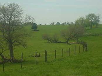 undoing of
Lt. Brandenstein. A series of quick and
deadly volleys came from the edge of the wheat field where a fence was catching
the skirmishers and Brandenstein. The
Union skirmishers returned fire and followed the Confederate skirmishers back
into the woods at a position approximately left of the trees in this picture on
the left side of the
undoing of
Lt. Brandenstein. A series of quick and
deadly volleys came from the edge of the wheat field where a fence was catching
the skirmishers and Brandenstein. The
Union skirmishers returned fire and followed the Confederate skirmishers back
into the woods at a position approximately left of the trees in this picture on
the left side of the 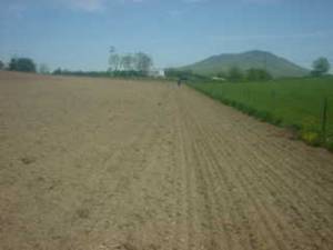 fence.
At a point of some sixty feet (20 paces), the 74th
skirmishers found themselves starring into the face of the Confederate
regiments attempting to flank this part of the Union line. Major Blessing ordered the men to fall back
to their 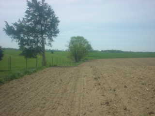 left –
towards the present day road. The ground
rises out of this small hollow as one can see in these pictures. The men had retreated about sixty feet to
another fence while receiving “torrents of musket-balls.” Bret and I suspect that this second fence
could be in the location of the fence seen in these three pictures…the initial
fence possibly being on the other side of the small creek that is barely
visable to the left of the fence (above and to the left). Seeing the predicament of the 74th,
the 75th sent forward companies to assist as Captain Wiedrich’s
three pieces began to load canister.
left –
towards the present day road. The ground
rises out of this small hollow as one can see in these pictures. The men had retreated about sixty feet to
another fence while receiving “torrents of musket-balls.” Bret and I suspect that this second fence
could be in the location of the fence seen in these three pictures…the initial
fence possibly being on the other side of the small creek that is barely
visable to the left of the fence (above and to the left). Seeing the predicament of the 74th,
the 75th sent forward companies to assist as Captain Wiedrich’s
three pieces began to load canister.
By this point,
While holding their position, the
The 74th didn’t participate in
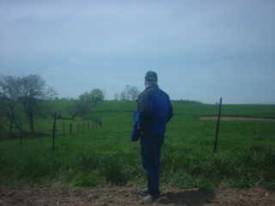 Bret here is
contemplating the place where the initial exchange of skirmishers occurred on
that June day. There is little in the
way of development or significant change to this part of the battle field.
Bret here is
contemplating the place where the initial exchange of skirmishers occurred on
that June day. There is little in the
way of development or significant change to this part of the battle field.
 The right
side of the
The right
side of the
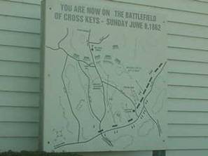
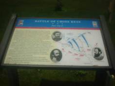
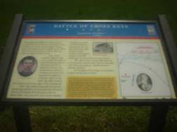 Here are
the examples of the signage that has been put in place for the benefit of
travelers. The work to preserve the
battlefield is discussed at
this website and at
this one. The Shenandoah Valley
Battle Fields foundation has worked in various ways with land owners to
preserve what is relatively undeveloped land.
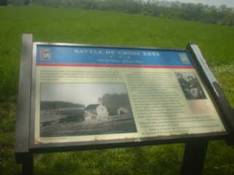
Here are
the examples of the signage that has been put in place for the benefit of
travelers. The work to preserve the
battlefield is discussed at
this website and at
this one. The Shenandoah Valley
Battle Fields foundation has worked in various ways with land owners to
preserve what is relatively undeveloped land.
 Any one
planning a trip to the battlefield should spend time studying the Shenandoah At War website. Packed with a lot of great information, this
site truly is an example of how history, conservation, and tourism promotion can
be brought together in a truly remarkable and professional manner.
Any one
planning a trip to the battlefield should spend time studying the Shenandoah At War website. Packed with a lot of great information, this
site truly is an example of how history, conservation, and tourism promotion can
be brought together in a truly remarkable and professional manner.
Also worth having if you plan to visit is the map packet created
by Mark Collier for
the Battle of Cross Keys. Through
the use of a printed Mylar slide and three topographical maps printed with
troop positions, this map set is a great bargain for less than $10. The packet includes a brief description of
the battle, an order of battle, and most importantly THE MAPS. Highly recommend this map set to anyone.
Also, be sure to read through Lt. Col. Hamm’s report on the battle
and have a copy of it with you if you visit.
Again, don’t walk on private property without permission of the
owners.
Bibliography
![]() Battle of Cross Keys
– Mark C. Collier, 1996.
Battle of Cross Keys
– Mark C. Collier, 1996.
![]() Battlefield –
Peter Svenson, Faber & Faber,
Battlefield –
Peter Svenson, Faber & Faber,
![]() The Battles of Cross Keys and
The Battles of Cross Keys and
![]() The Valley of
the Shadow - John D
Imboden, "Stonewall Jackson in the Shenandoah," Battles and
Leaders of the Civil War, Volume II, pages 282-298.
The Valley of
the Shadow - John D
Imboden, "Stonewall Jackson in the Shenandoah," Battles and
Leaders of the Civil War, Volume II, pages 282-298.
![]() Research notes of Bret Coulson,
Research notes of Bret Coulson,