Hoh
updated: 1996
Scale 1:62,500
(1 inch to the mile)
Contour Interval: 100 feet
|
|
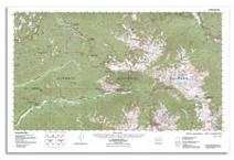
Seven Lakes Basin- Hoh updated: 1996 Scale 1:62,500 Contour Interval: 100 feet |
The Seven Lakes Basin - Hoh map includes the Seven Lakes Basin Loop and High Divide, as well as the entire Hoh Rain Forest trail. This popular area is located in Olympic National Park, in the Northwest corner of the Olympic Mountains in Washington State, USA.
This map includes Trailheads at the Sol Duc Hot Springs Resort and campground, the Olympic Hot Springs, and the Hoh River Campground and Visitor Center. There is a rich system of trails connecting these three trailheads, with numerous loops available, as well as several well known off-trail traverses, including the north end of the Bailey Range. The area includes the high country of the High Divide, Appleton Pass, Boulder Lake, and Glacier Meadows (the base camp for climbing Mount Olympus), as well as the world famous temperate rain forest of the Hoh Valley, and the ancient forest of the Sol Duc. It also includes the only two hot springs on the Olympic Peninsula, the Sol Duc Hot Springs Resort, and the primitive Olympic Hot Springs at Boulder Creek.
|
Special Features:
Trails are more accurate and up-to-date than any other published map we are aware of. This map puts some of the most impressive and sought after destinations in Olympic National Park on one seamless and complete map. (This is the only large scale map to do so, the area is cut in half on quad maps.) Woodland shading updated from recent maps and aerial photos to show timberline patterns with the greatest possible detail, as well as harvest/regeneration activity, wildfires and other changes not shown on USGS or other commercial maps. Map coordinates are placed on the North American Datum of 1983 (NAD83), and UTM coordinates are shown compatible with the National Coordinate System. (There is no private land shading on this map because all the land shown is public.)
|