updated: 1994
Scale 1:24,000
(1 inch = 2,000 feet)
Contour Interval: 40 feet
|
|
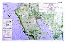
Ozette Beach Loop updated: 1994 Scale 1:24,000 Contour Interval: 40 feet |
The Ozzette Beach Loop map is a special map centered on the most popular loop trip in Olympic National Park. It includes the north end of Ozette Lake, Cape Alava (the western-most point of the state of Washington), and Sand Point.
In addition to the Ozette - Cape Alava - Sand Point Loop, this map includes the Ozette Reservation, the site of the famous "Ozette Dig". Unique among Custom Correct maps, this map is at 1:24,000 scale, matching the USGS 7.5 minute quads. Rather than the traditional woodland shading, it depicts an aerial photo image in green, with all the usual information overlaying that. (This area is also totally covered by the North Olympic Coast map, though at a smaller, less detailed scale.)
|
Special Features:
Trails, including headland trails are more accurate and up-to-date than any other published map we are aware of. Maximum passable tide heights are shown for locations that must be rounded at low tide. Trail and beach distances are both shown. The map includes an aerial photo image that brings the land to life.. Map coordinates are placed on the North American Datum of 1983 (NAD83), and UTM coordinates are shown compatible with the National Coordinate System. |