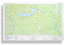
Happy Lake Ridge
updated: 1994
Scale 1:62,500
(1 inch to the mile)
Contour Interval: 100 feet
|
|
Lake Crescent - Happy Lake Ridge updated: 1994 Scale 1:62,500 Contour Interval: 100 feet |
The Lake Crescent - Happy Lake Ridge map is centered on beautiful Lake Crescent in Olympic National Park. It includes both Sol Duc Hot Springs and Olympic Hot Springs, the middle reach of the Elwha River, and all the trails in the Happy Lake and Aurora Ridge area between them. It also includes Olympic National Forest and Washington State Department of Natural Resources trails to the north. It is located on the northern edge of the Olympic Mountains in Washington State, USA.
This map includes some of the top road-access attractions in Olympic National Park, as well as the only seamless coverage of the less known wilderness between them. Happy Lake Ridge, Aurora Ridge and the North Fork Sol Duc are criss-crossed with trails and potential loop trips. Depth contours are shown on Lake Crescent, Lake Aldwell, and Lake Mills (none available for Lake Sutherland).
|
Special Features:
Trails are more accurate and up-to-date than any other published map we are aware of. This is the only large scale topographic map to show all of Lake Crescent on one map, and also the only one to show the trail system to the south of the Lake on only one map. It is the only map to show most of these trails accurately. Depth Contours (60 ft) are shown for Lake Crescent, Lake Aldwell and Lake Mills. This is the only topographic map to show the newer Sadie Creek (DNR) and Mount Muller (Olympic National Forest) trails. Woodland shading updated to show timber harvest/regeneration activity, wildfires and other changes not shown on USGS or other commercial maps. Map coordinates are placed on the North American Datum of 1983 (NAD83), and UTM coordinates are shown compatible with the National Coordinate System. |