Valley -
Skokomish
updated: 1992
Scale 1:62,500
(1 inch to the mile)
Contour Interval: 100 feet
|
|
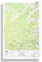
Enchanted Valley - Skokomish updated: 1992 Scale 1:62,500 Contour Interval: 100 feet
|
The Enchanted Valley - Skokomish map includes the East Fork of the Quinault River (including Enchanted Valley), The North Fork Skokomish River, Upper South Fork Skokomish River, and the surrounding High Country in the south-east corner of Olympic National Park, as well as the Wonder Mountain Wilderness in Olympic National Forest, in the Olympic Mountains in Washington State, USA.
It covers the entire Enchanted Valley Trail from Graves Creek to Anderson Pass. It Covers the entire North Fork Skokomish River Trail, and all it's connecting trails from Staircase to the Headwaters of the Duckabush, LaCrosse and O'Neil Passes. It includes Sundown Lake, Six Ridge and the upper (unroaded) South Fork Skokomish Trail.
|
Special Features:
Trails are more accurate and up-to-date than any other published map we are aware of. This area was mapped especially poorly on previous maps, and is inconveniently cut-up by quad boundaries. Enchanted Valley - Skokomish is by far the most accurate map of the trails in this area. Woodland shading has been updated from recent 7.5 minute maps (where available) and recent photos elsewhere to more accurately show vegetation patterns near timberline, as well as wildfires and other changes not shown on USGS or other commercial maps. This is the only large scale topographic map of the Wonder Mountain Wilderness.
|