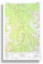
Valley
updated: 2001
Scale 1:62,500
(1 inch to the mile)
Contour Interval: 100 feet
|
|
Elwha Valley updated: 2001 Scale 1:62,500 Contour Interval: 100 feet
|
The Elwha Valley map is centered on the Elwha River Valley, in Olympic National Park, in the North Central part of the Olympic Mountains in Washington State, USA.
It covers the entire Elwha River Trail system, from Whiskey Bend to Low Divide and Elwha Basin. It also includes Hurricane Ridge on the North, the southern Bailey Range on the west, and the headwaters of the Dungeness and Dosewallips on the East.
|
Special Features:
Trails are more accurate and up-to-date than any other published map we are aware of. Woodland shading has been updated from recent 7.5 minute maps (where available) and recent photos elsewhere to more accurately show vegetation patterns near timberline, as well as wildfires and other changes not shown on USGS or other commercial maps. Map coordinates are placed on the North American Datum of 1983 (NAD83), and UTM coordinates are shown compatible with the National Coordinate System. The most recent update included revised spot elevations throughout the map, including the use of a larger type to make them more readable.
|