updated: 1999
Scale 1:62,500
(1 inch to the mile)
Contour Interval: 50 feet
Includes National Forest
Wilderness Map information
printed on back.
|
|
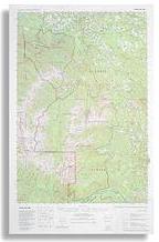
Buckhorn Wilderness
updated: 1999 Scale 1:62,500 Contour Interval: 50 feet Includes National Forest |
The Buckhorn Wilderness map is centered on the Buckhorn Wilderness, in Olympic National Forest, on the Northeast corner of the Olympic Mountains in Washington State, USA. It includes portions of Olympic National Park and Olympic National Forest.
It includes the Dungeness and Quilcene River drainages, Mount Constance, Mount Deception, the Needles and Mount Townsend Areas. All the trails in, or leading in to the Buckhorn Wilderness are included on this map.
|
Special Features:
Trails are more accurate and up-to-date than any other published map we are aware of. National Forest Roads are up-to-date, with current road numbers. Private land is identified with a shading pattern. Woodland shading is updated to show timber harvest/regeneration activity, wildfires and other changes not shown on USGS or other commercial maps. Buckhorn Wilderness is one of four Custom Correct (tm) maps that have been adopted by the Olympic National Forest as their official Wilderness Maps. Rather than create a separate map series at taxpayer expense, the US Forest Service chose the best maps on the market, and contracted to place their Wilderness information on the back. This special relationship has continued since 1986. Map coordinates are placed on the North American Datum of 1983 (NAD83), and UTM coordinates are shown compatible with the National Coordinate System. |