updated: 1997
Scale 1:62,500
(1 inch to the mile)
Contour Interval: 80 feet
|
|
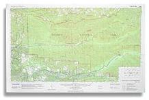
Bogachiel Valley updated: 1997 Scale 1:62,500 Contour Interval: 80 feet |
The Bogachiel Valley map includes the entire Bogachiel Rain Forest corridor of Olympic National Park, and the middle Hoh River Valley in the Northwest corner of the Olympic Mountains in Washington State, USA. It includes portions of the surrounding Olympic National Forest.
It includes the entire Bogachiel River Trail system from Undi Road on the west up to Mink Lake and Sol Duc Hot Springs on the east. It includes the middle Hoh River Valley, from Highway 101 up to the Hoh Campground and trailhead.
|
Special Features:
Trails are more accurate and up-to-date than any other published map we are aware of. Private land is identified with a shading pattern. Woodland shading updated to show timber harvest/regeneration activity, wildfires and other changes not shown on USGS or other commercial maps. Map coordinates are placed on the North American Datum of 1983 (NAD83), and UTM coordinates are shown compatible with the National Coordinate System. |