Olympic
Coast
updated: 1992
Scale 1:62,500
(1 inch to the mile)
Contour Interval: 40 feet
Maximum Tide Heights shown for passing headlands.
|
|
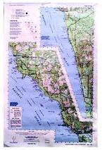
South Olympic Coast updated: 1992 Scale 1:62,500 Contour Interval: 40 feet Maximum Tide Heights shown for passing headlands. |
The South Olympic Coast map includes the entire southern half of the coastal strip of Olympic National Park, on the Pacific Coast of Washington State, USA. The map extends from just north of La Push and the Quillayute River on the north, to the Queets River on the south.
In addition to the south wilderness coast, this map includes the Kalaloch strip of Highway 101 in Olympic National Park, and the Quileute and Hoh Reservations..
|
Special Features:
Trails are more accurate and up-to-date than any other published map we are aware of. Maximum passable tide heights are shown for locations that must be rounded at low tide. Trail and beach distances are both shown. This map covers the wilderness coast from the La Push to the Hoh River, and the Kalaloch Strip.. Contours and other features are rescribed and reduced from 7-1/2' Quads, not from the old 15' quads. People have died falling from bluffs that don't even show on the old maps (or their derivatives). Yet it covers as much coastline as 5 USGS 7-1/2' Quads (and costs less than one!) Woodland shading has been updated from recent aerial photos to more accurately show timber harvest and other changes not shown on USGS or other commercial maps. |